Geomagnetic Storm
Short explanation: Geomagnetic storm (solar storm) disturbs satellite navigations so that the received position signal is less accurate.
Details: A geomagnetic storm, also known as solar storm, is the result of solar flares. Solar flares are large explosions on the sun surface that releases energy into space. This result in electromagnetic radiation at diverse wavelengths, including radition in the spectrum used for satellite communication.
When the radiation from the solar flare reaches the earth orbit it disturbs the earth magnetosphere, causing disruption and delays in the satellite radio signals including the time signals sent by GNSS (Global Navigational Satellite System) satellites. These GNSS signal interference causes the receiver to calculate a less precise position.
UAS and micro-copters
Mikrokopter and other multi-rotors rely on GNSS receiver for position-hold and for way-point programmed flight. For this reason it is very important to receive an accurate satellite signal.
All GNSS, whether that is GPS, Galileo, Glonass or Beidou, are affected by geomagnetic storm,
During geomagnetic storm the MikroKopter is more inprecise in position-hold and can even have sudden large movements. If you fly while there is geomagnetic storm it does not mean you will encounter problems however there is an elevated risk.
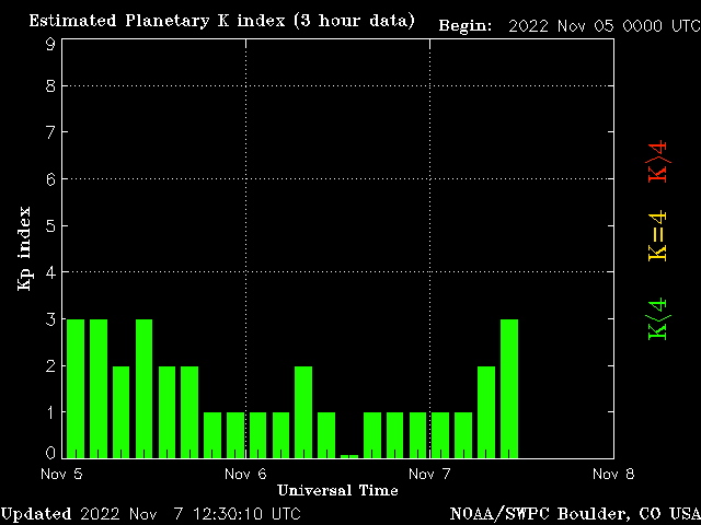
Geomagnetic distubance is meassued as a Kp index, from 0-9.
- Green 0-3: Calm
- Yellow 4: Unsettled
- Red 5-9: Storm.
It is recommend to only fly when Kp index is calm.
Geomagnetic Forecast
The easy way to read both past and forecasted geomagnetic Kp index is by use of the Geomag Forecast application.Online Geomagnetic past data
Past Kp index can be viewed as a graph at the NOAA site and also at N3KL site but server is often down.

Android App Solar Activity Kp-Index that displays the graph. Android widget Solar Activity Monitor displays Kp index.
Reading the Planetary K Index graph
The graph is not a space-weather-forecast (geomagnetic forecast), it is not even a space-weather-now-cast, rather the graph shows Kp index for the last completed 3 hours segment, i.e. past data. If the recent 3 hour segment was "calm" (green) we can hope for the current 3 hours segment will also be calm, but we can not be sure and we only see how it was after the 3 hours segment is finished. Usually the Kp index is updated ~30 mn after the segment is finished.
The date and time of the graph will require a bit of time zone calculation. The graph uses UTC (Coordinated Universal Time) that is same as GMT (Greenwich Mean Time) as used in Britain during winter time! During summer time, officially known as Daylight-Saving-Time (DST), the timezone in Britain is called BST (British Summer Time) = UTC+1.
Most EU countries use CET (Central European Time) which in winter = UTC+1. In summer it is called CEST (Central European Summer Time) and is = UTC+2. Examples:
- In summer time on e.g. 2016-06-03 the UTC segment 0:00 - 2:59 is CEST 2:00 - 4:59. The graph is updated 30 mn. after segment finished = ~3:30 UTC = ~5:30 CEST.
- In winter time on e.g. 2016-12-01 the UTC segment 3:00 - 5:59 is CET 4:00 - 6:59. The graph is updated 30 mn. after segment finished = ~6:30 UTC = ~7:30 CET.
On the front page of the MikroKopter wiki there is a single field aggregation of the Kp index. This appears to take the most severe Kp index of the last dygn (24 hours). That is not very useful, what matters is the most recent segment and even better forecasted data.
Forecast Kp data
NOAA has 3 day forecast that is updated twice per day at 00:30 and 12:30 UTC listed as text. 3-Day Forecast. Note: This forecast is often not precise, the actual Kp index may be HIGHER or lower than forecasted.
Android app, forecast Kp: Magnetology
Windows app, forecast Kp: Geomag Forecast
Historical Kp data
Historical Kp index data: NOAA archive.
MikroKopter diviation chart
With KopterTool from MikroKopter you can check the current geomagnetic accurary. In the main screen (scope screen), click MKGPS, a window with an overview of satellites received is displayed. click "Deviation Map" and let the MikroKopter stand still on ground and collect data for 5-10 mn.
More information
Article and forecast graphs from Iceland weather service
International Service of Geomagnetic Indices
Quicklook Kp Index, GFZ Potsdam
Tags: Geomagnetic storm, solar storm, GNSS, Mikrokopter, octocopter, UAS
Page link: <http://foersom.org/HowTo/GeomagneticStorm.html>
Edited: 2017-09-07